
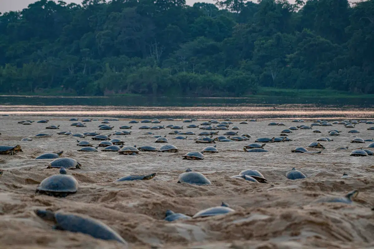
A research team from the **University of Florida** has managed to confirm the **largest known nesting site** of the **South American river turtle (Podocnemis expansa)**, using [**drones and advanced statistical models**](https://noticiasambientales.com/innovacion/el-uso-de-drones-podria-revolucionar-la-expansion-de-las-selvas/).
This approach, more precise and less invasive than traditional methods, allowed for the **more accurate detection** of the presence of **over 41,000 turtles** in the **Guaporé River**, in an unprecedented reproductive aggregation event.
## A key species under threat
The giant river turtle faces **poaching and habitat loss**. Despite its **fundamental ecological role** in aquatic ecosystems, the **Podocnemis expansa** is seriously threatened by:
– [Illegal hunting](https://noticiasambientales.com/animales/caza-ilegal-de-un-puma-concolor-en-chaco-advierten-sobre-multas-millonarias-y-responsabilidad-penal/)
– Alteration of river habitats
– Lack of precise data for its protection
This study provides **critical information** to design **effective conservation strategies** based on **solid scientific evidence**.
## Drones and mathematical models: a revolution in wildlife monitoring
The use of **drones in wildlife studies** is not new, but this work stands out for its **level of technical refinement**. The researchers:
– Generated **orthomosaics**: high-resolution aerial images composed of thousands of overlapping photographs
– Developed **statistical models** to correct errors such as duplications due to movement or omissions due to limited visibility
– Applied **visual marking** to 1,187 turtles with white paint to track their trajectories
## From overestimation to precision
The results show how conventional methods can **distort the population reality**:
– Ground observers counted **16,000 individuals**
– The initial image analysis indicated **79,000 turtles**
– The adjusted model yielded a more accurate figure: **41,000 specimens**
“**This level of precision makes the difference between making informed decisions or acting blindly**,” highlight the authors.
## Scalability and application to other species
The technique is already being used in monitoring other species:
– **Sea lions** marked with paint
– **Elks** with fluorescent collars
– **Mountain goats** followed with drones and sensors
In all cases, the goal is to **maximize data quality** and **reduce human impact** on the natural environment.
## Regional projection and data accumulation
The **Wildlife Conservation Society ([WCS](https://argentina.wcs.org/))** announced its intention to apply this system in other regions where the **giant river turtle** is present. The **accumulation of multi-temporal and geographic data** will allow:
– Detecting real population trends
– Defining priority areas for action
– Optimizing conservation resources in critical areas
*Cover photo: Omar Torrico*