Indonesia discovered that the deadly eruption and tsunami that occurred in 2018 could have been avoided. It is about the volcano Anak Krakatau, which would have given a warning about the collapse that caused those natural disasters that killed hundreds of people and injured thousands of inhabitants of Java and Sumatra, according to the study published in the journal Geophysical Research Letters.
According to the associate professor of geosciences at Penn State and co-author of the study, Christelle Wauthier, these episodes occurred as a consequence of the volcano’s instability. This happens when volcanoes are unstable, increasing the chances of collapsing “catastrophically” and causing a tsunami.
In this sense, the expert adds that if at that time they had had the necessary instruments to detect an acceleration or a change in deformation behavior, they could have predicted and prevented the deaths that occurred at that time. It is a remote sensing technique called Interferometric Synthetic Aperture Radar (InSAR) with the ability to create high-precision maps, marking changes over time.
According to experts, remote sensing data can help track ground movements or surface deformation, using radar satellites with the necessary sensitivity to detect the slightest change.
A technique that is not new, but very useful: remote sensing
While it is true that the InSAR technique is not new, what caught the attention of scientists is the capacity of this tool to analyze a huge amount of data. To access this information, the team had to use the high-performance Roar computers managed by the Institute for Computational and Data Sciences at Penn State.
Despite the fact that data storage and processing require time and resources, it can become a promising technique for monitoring active oceanic volcanoes in real-time. According to experts, the volcano grows as it erupts, until it reaches a threshold where the fault can no longer support it, leading to collapse.
On the other hand, researchers add that there are other ways to track volcano deformation, such as land-based GPS instruments, which are difficult to find in places like Anak Krakatau, especially due to security issues, permits, and funding.
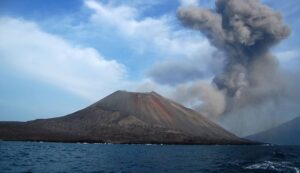
 Anak Krakatau Volcano, Indonesia. Photo: Google Maps.
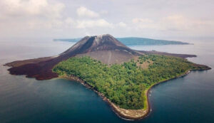
What are the dangers of an active volcano?
A volcanic eruption is the process of magma reaching the surface. In turn, eruptions tend to have different stages and processes, which depend on the characteristics of the magma and the eruption process itself.
In general, active volcanoes present several dangers, among the main ones are ash fall, gas emissions, lava flows, pyroclastic flows, lahars, landslides, and tsunamis.
Do you already know our YouTube channel? Subscribe!