
Weather conditions will become more adverse starting on Monday with the development of a cyclone in the area, culminating in a Tuesday with the August rain, characteristic of a stormy weather.
We conclude the first half of August under a pattern of stability that has persisted for a considerable time in the central region of Argentina; in fact, the last precipitations in the AMBA (Metropolitan Area of Buenos Aires) were recorded on the first day of the month.
However, everything indicates that this situation will change in the coming hours. Initially, a weekend with abundant cloudiness was expected with some periods of instability that could cause isolated showers.

Subsequently, as anticipated, a significant adverse weather event will develop affecting a large part of the central region of the country, where Buenos Aires City and the conurbation could be impacted by phenomena of considerable magnitude in terms of rainfall and winds.
Weekend Weather Forecast for Children’s Day in Buenos Aires
After a cold Friday morning in the AMBA, with minimum temperatures ranging from 5 to 7 °C in the Capital Federal and approaching 0 °C in the Greater Buenos Aires, the afternoon goes by with partly cloudy skies, east winds, and a quite cool atmosphere, with temperatures barely rising above 10 °C by mid-afternoon.
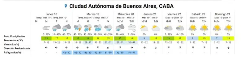
For Saturday in Buenos Aires, a minimal temperature variation was forecasted, with another cold dawn and an afternoon that will remain quite cool.
The most relevant meteorological aspect will be the gradual increase in cloudiness as an upper-level disturbance advances through the central area of Argentina.
This will increase instability after sunset, and the possibility of some weak and isolated showers towards the night is not ruled out, with precipitation accumulations not exceeding 5 mm.
On Sunday, Children’s Day, it started with very cloudy skies and unstable conditions, at least during the first early hours of the morning. Then, the formation of fogs and fog banks is likely to reduce visibility at dawn, in a context of cold and humid weather in the region. The rest of the day will continue with predominance of clouds over the sun and a fairly cool atmosphere, with maximum temperatures around 15 °C.
Cyclone Will Bring Heavy Rains to the AMBA
On Monday, it will dawn again very cloudy and cool in the AMBA region, with temperatures near 12 °C in the Capital Federal and east winds that will intensify from moderate to regular.
The weather conditions will progressively worsen after noon, anticipating the first isolated rains and storms linked to the cyclone process that will begin to impact the center and north of Argentina.
By Monday night, the likelihood of rain and storms in Buenos Aires will be considerably higher.

The peak of bad weather activity over Buenos Aires is expected for Tuesday the 19th, with the displacement of a low pressure system from the Litoral towards the east of Buenos Aires province.
This will cause an abrupt drop in surface pressure, reaching values that will probably be below 1000 Hpa.
It will be a day with typical conditions of a storm in the city and its surroundings, where strong winds with gusts, intense and abundant rains, and also some storms will combine.
Regarding the winds, gusts with intensities of 45 to 60 km/h could be recorded, blowing initially from the east quadrant and then shifting to the south/southwest by Wednesday the 20th.
As for the August rains and storms, it is expected that they will be persistent throughout the day, with an intensity that will vary from moderate to heavy.
Various forecast models coincide, both in their main executions and in their ensemble projections (probabilistic forecasts), that it is very likely that over 40 mm of rain will be exceeded during that day.
Many of these prediction models estimate that the precipitation throughout Tuesday the 19th would be in a range of 50 to 70 mm over the AMBA. These values are comparable to the normal precipitation for the entire month of August in Buenos Aires (70.3 mm, according to CABA’s climatology).
For Wednesday, a last batch of isolated and residual August rains is anticipated during the early hours of the day, associated with the rear portion of the low-pressure system (occluded front).
Subsequently, the weather will improve suddenly with a drastic decrease in cloudiness and winds from the west, facilitating the entry of a very dry and stable air mass to the region.