
August 2025 could be remembered in the collective memory as the wettest and stormiest closure of the year. The traditional “Santa Rosa storm” will arrive with historical precision between August 30 and September 1, driven by a cyclogenesis that will intensify rainfall, winds, and electrical activity in a large part of the country.
Forecasts agree: starting from Friday the 29th, the warm and calm atmosphere will give way to increasing instability. On Saturday the 30th, a low-pressure center —a cyclogenesis— will form, triggering strong storms and heavy rainfall in provinces such as Buenos Aires, Córdoba, Santa Fe, Entre Ríos, and La Pampa. Precipitations could result in historical accumulations in some areas.
Traditionally associated with Santa Rosa Day (August 30), this storm is statistically supported: around that date, the phenomenon repeats in more than 50% of the years, according to records from the National Meteorological Service. This year, the coincidence between myth and science takes on special resonance.
“Santa Rosa” between myth, climate, and real risk
After days of clear skies and rising temperatures, the context sets the perfect stage for these types of storms. The circulation of warm and humid air from the north collides with cold fronts from the south, generating the typical instability of the end of winter.
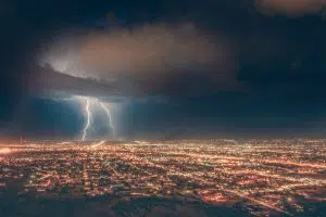
A cyclogenesis can unleash torrential rains, gusts, and sustained lightning. This year, it is not only expected to arrive but to do so with intensity: some models warn of accumulations that could triple the monthly average in areas of the AMBA.
For the central and northeastern provinces, Sunday the 31st will be the most critical day. Extensive rains are expected throughout the day, accompanied by sustained winds and strong gusts.

What you need to know: what to expect and how to protect yourself
In areas such as Greater Buenos Aires, Córdoba, Santa Fe, or Entre Ríos, a lot of rain is anticipated in a few hours and wind gusts that could exceed 50 km/h. On the Atlantic coast, winds could reach up to 85 km/h.
Do not rule out severe storms: intense rains, electrical discharges, occasional hail, and gusts are part of the scenario. In the context of the “Tornado Alley,” the central region is usually the scene of supercell storms, although it is not common for them to develop into tornadoes at this time of year.
It is crucial to stay informed through the official channels of the SMN, avoid unnecessary travel, secure loose objects, and protect animals and belongings. In case of an electrical storm, avoid taking shelter under trees or handling connected metal objects.
The 2025 Santa Rosa storm arrives reinforcing the connection between climatology, cultural heritage, and ecological urgency. It is not only a meteorological event but an opportunity to remember how much we depend on nature and why protecting it is more necessary than ever.