
The winter cold snap is back, marking the fleeting “spring” that deceived us for weeks has come to an end.
After an unusually warm period in much of the country, where thermometers recorded temperatures above normal for the season, the Argentinian winter is regaining its dominance with a marked drop in temperatures.
Get ready to dust off your winter clothes, because this week the winter cold is back in full force, especially in the central and southern regions of the country.
A forecasted turn: the incursion of cold air masses
The National Meteorological Service (SMN) has been categorical in its forecast: coats and scarves will once again be essential elements of our attire.

This drastic change in weather will originate from the entry of powerful cold air masses that, starting mid-week, will cause a notable and sudden drop in minimum temperatures.
The days of gentle breeze and soft sunlight will be left behind, giving way to chilly days that will remind us that we are in the midst of winter.
#BuenLunes Argentina
🌡 El aire cálido continúa en las provincias de norte argentino y deja una mañana templada con nieblas.🥶 El centro y sur del país tendrá varios ingresos de aire frío está semana, por lo que volverán las temperaturas invernales.
+ https://t.co/HR4LGtOd3P pic.twitter.com/7co1iropRk
— SMN Argentina (@SMN_Argentina) July 21, 2025
Weather details for the AMBA: weeks of winter cold ahead
For residents of the Autonomous City of Buenos Aires and its surroundings, the forecast from SMN details a week of progressive cooling:
- Tuesday: The day will be partly cloudy. The minimum temperature will be 11 degrees Celsius, while the maximum will reach 16 degrees Celsius. A south wind will blow, with gusts that could reach 22 kilometers per hour, anticipating the upcoming change.
- Wednesday: This day will mark a significant and noticeable temperature drop. The minimum will be only 7 degrees Celsius, and the maximum will not exceed 13 degrees Celsius. The wind will continue to blow from the south, accentuating the cold thermal sensation.
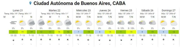
- Thursday: The cold will persist strongly. The minimum temperature will remain at 8 degrees Celsius, while the maximum will experience a slight increase compared to the previous day, reaching 15 degrees Celsius. The wind will change its direction, blowing from the northwest.
- Friday: The minimum will return to the double digits, registering 11 degrees Celsius, although the maximum will remain the same as Thursday. It will be a brief respite before a new drop.
- Saturday: A new drop in the minimum temperature is expected, which will be at 8 degrees Celsius, while the maximum will be 13 degrees Celsius.
- Sunday: The culmination of this cold wave will be felt more intensely. The minimum will decrease even further, reaching 6 degrees Celsius, and the maximum will barely reach 12 degrees Celsius, consolidating a truly winter day.