
In the midst of the extreme cold in Argentina, due to the polar cold wave affecting a large part of the country, surprising images were captured.
In the last hours, a 30-meter-high waterfall was completely frozen in the province of Neuquén.
The landscape left behind seems taken from another world and the images quickly circulated on social media. It happened in the town of Caviahue, where temperatures reached extreme levels.
Extreme Cold in Argentina and a Winter Postcard Amazing the Country
The images of the frozen waterfall quickly went viral on social media, showing a thick layer of ice covering the entire waterfall.
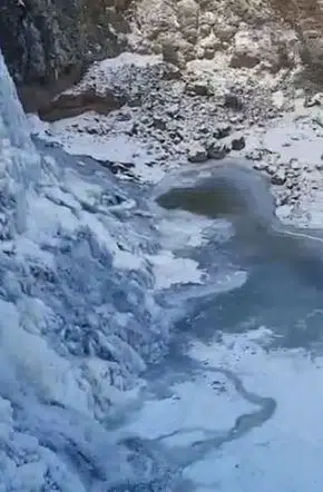 The Neuquén waterfall in a postcard of the polar cold wave. (Photo: X).
Caviahue, one of the tourist gems of the Argentinian Patagonia, is located more than 1600 meters above sea level and is known for its volcanic environment, natural hot springs, and ancient Araucaria forests.
In this mountainous region, temperatures dropped below -20 °C, causing the complete freezing of the waterfall, something uncommon even in Patagonian winters.
The scene took place in the context of a polar cold wave affecting several provinces in the south and center of the country, with temperature records breaking for this time of the year.
The Impact of Extreme Cold and Tourist Attraction
Specialists pointed out that these phenomena are the result of the combination of polar dry air and clear nights. This enhances heat loss in the environment.
While it is a striking natural event, it is also a reminder of the impact of climate change, which generates more extreme and unpredictable winters in the southern hemisphere.
At the same time, the freezing of the waterfall sparked the interest of tourists and photographers, turning the site into an unexpected winter attraction.
Local authorities recommended taking extreme precautions when visiting the area, due to the presence of ice on trails and roads.
How Long Will This Cold Wave Last?
The National Meteorological Service estimates that the conditions will persist until mid-week, with a probability of intense frosts during mornings and nights.
 The cold wave in Argentina. (Photo: NA).
From Thursday or Friday, a slight rise in temperatures could be recorded, although winter weather is expected to continue with new cold air incursions in the coming days.
Experts explain that this polar wave is due to the advance of a mass of air of Antarctic origin, which caused a sudden drop in temperatures in much of the country.
These types of events are common during winter, but this year they are occurring with a remarkable intensity.